
LFRMP
North East Local Flood Risk Management Plan 2016-2022
Six-year plan to manage flood risk in the north east now available to view
A plan setting out which local communities are most at risk from flooding and what is to be done to reduce that risk is published today. (Wed, June 22)
The North East Local Flood Risk Management Plan (LFRMP) has been produced under the Flood Risk Management (Scotland) Act 2009, which provides a strategic framework for considering appropriate mechanisms to manage flood risk across Scotland.
Covering the period from 2016-22, it addresses Potentially Vulnerable Areas (PVAs) in Aberdeenshire, Aberdeen City, and parts of Moray and the Cairngorms National Park area.
A range of measures to reduce risk have now been set out for 23 PVAs across the North East Local Plan District.
The LFRMP presents a summary of the objectives and measures to manage flood risk and details how they will be implemented, as well as timescales for delivery, funding arrangements and details of partnership working to deliver them.
Aberdeenshire Council, as Lead Local Authority for the North East District, has developed the LFRMP in conjunction with neighbouring authorities to cover that six year period.
This has involved partnership working and collaboration with Aberdeen City Council, The Moray Council, SEPA, Cairngorms National Park Authority and Scottish Water.
It has been prepared over a number of years and the planned actions are based on the best evidence available on the causes and consequences of flooding.
Through this risk-based and plan-led approach, flood management will improve for individuals, communities and businesses at risk across the north east.
It is not designed to be a reaction to the flooding during Storm Frank earlier this year, which affected a number of communities in the plan area.
SEPA (Scottish Environmental Protection Agency) published a Flood Risk Management Strategy for Scotland, approved by the Environment Minister in December 2015.
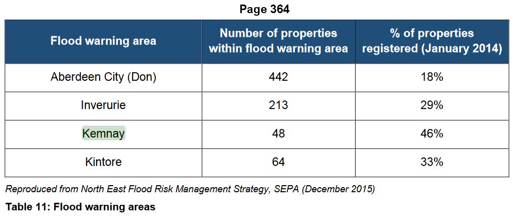
While Kemnay does not feature in the plan, discussions will continue with SEPA regarding the designation of Kemnay as a PVA.
The Scottish Government’s allocation of the Flooding Capital Grant will assist in funding the work, and the plan has been published following agreement on the contents by all of the local authorities involved.
Chair of Aberdeenshire Council’s Infrastructure Services Committee (ISC), David Aitchison, said: “The Flood Risk Management Plan has been developed to reduce the devastating and costly impact of flooding in the north east. This plan-led approach will focus on where the risk of flooding and benefits of investment are greatest.
“There has been a substantial amount of work done over the past few years by the partner agencies to put together a plan with common objectives which will coordinate the efforts of all organisations that tackle flooding.
“There is still some flexibility for us to deal with serious issues, such as Ballater, so long as it does not impact negatively on delivery of the agreed plan. Given the major impact the flooding of the Dee had on the community at the start of the year, it has been decided to bring this study forward from the original proposed delivery in the next planning cycle in 2022 – 2027.
“We are also taking forward some measures in relation to the protection of property and raising awareness of flood issues in Kemnay while discussing with SEPA its possible future inclusion as a Potentially Vulnerable Area.”
ISC vice chair, Stephen Smith, said: “The publication of this local plan sets out a prioritised list of actions for flood protection works; flood protection studies; strategic improved understanding; and flood warning schemes across the majority of the north east.
“Action is being taken where the strategic appraisal indicates that an action, or group of actions is likely to address the flooding problem, and where initial assessments of technical, economic and environmental feasibility have indicated it is worth progressing to a detailed study.
“We hope this will offer some security for those communities most at risk of flooding, setting out what is going to be done, when and by whom.”
Part of Aberdeenshire is also within the Tay Estuary and Montrose Basin Local Plan District, with the Laurencekirk, Fettercairn and Marykirk PVA’s included in this District.
The Tay Estuary and Montrose Basin Local Flood Risk Management Plan can be viewed on the Angus Council website.
A hard copy of the north east plan can be viewed at Aberdeenshire Council’s Carlton House office in Stonehaven and copies will be placed in some local libraries.
It can also be viewed on the Aberdeenshire Council website.
SEPA’s Flood Risk Management Strategy for the north east can be viewed on SEPA’s website.
Flood Risk Management (Scotland) Act 2009
The Flood Risk Management (Scotland) Act 2009 adopts a proactive approach to managing flood risk in Scotland.
As Lead Local Authority for the North East region under the Act, Aberdeenshire Council have produced the North East Local Flood Risk Management Plan. The Plan has been published in partnership with Aberdeen City, the Moray Council, SEPA, Scottish Water, the Forestry Commission and the Cairngorms National Park Authority.
SEPA were also tasked with leading the development of Flood Risk Management Strategies, working in partnership with Local Authorities, Scottish Water, the Forestry Commission and the National Park Authorities.
Local Authorities and SEPA carried out consultation on the draft Flood Risk Management Strategies and Local Flood Risk Management Plans. Feedback from these consultations was collated by Aberdeenshire Council and SEPA and fed back into both the Local Flood Risk Management Plan and the Flood Risk Management Strategy for the North East Local Plan District.
Further information can be found on the SEPA and Scottish Government website.
North East Local Flood Risk Management Plan 2016-2022
North East Local Flood Risk Management Plan 2016-2022
Tay Estuary and Montrose Basin Local Plan District 2016-2022
Tay Estuary and Montrose Basin Local Plan District 2016-2022
North East Flood Risk Management Strategy
North East Flood Risk Management Strategy
Clearance and Repair Schedule